Baildon Trail
- Paul Clarke
- Aug 4, 2024
- 5 min read
The Wharfedale line runs from Bradford Forster Square to Ilkley, via several stations, the first of which are Frizinghall and Shipley, which we have already visited on the Airedale line. Our first stop on the final leg of our tour of the City of Bradford is therefore at the town of Baildon, a charming stone built town with an attractive historic centre. The area has been occupied since the Bronze Age, and the town is named in the Domesday Book of 1086 as Beldone and Beldune. It developed a woollen industry during the Industrial Revolution, and for about three hundred years it host annual Gypsy Parties, a tradition that died out following World War II. Today, Baildon is a commuter town for people working in Bradford and Leeds. The walk also includes the tiny village of Tong Park, which is attached to the eastern edge of Baildon.
Baildon Railway Station was opened in 1876 by the Midland Railway, on what is now the Wharfedale Line; it closed in 1953, reopened and almost immediately closed again in 1957, and finally reopened in 1973. It has been reduced to a single track and platform station (there were original two) and the station building survives, but in private ownership. We leave the station via the car park to reach Ridgewood Close, then turn right and follow this to Station Road. Here, turn left, cross the road at the zebra crossing, and stay on Station Road all the way until it ends at Baildon Road. Turn right and follow this, taking a detour along Hallfield Drive on the right to visit Baildon Hall. Now a club, this dates from the fourteenth century and is the oldest building in Baildon.
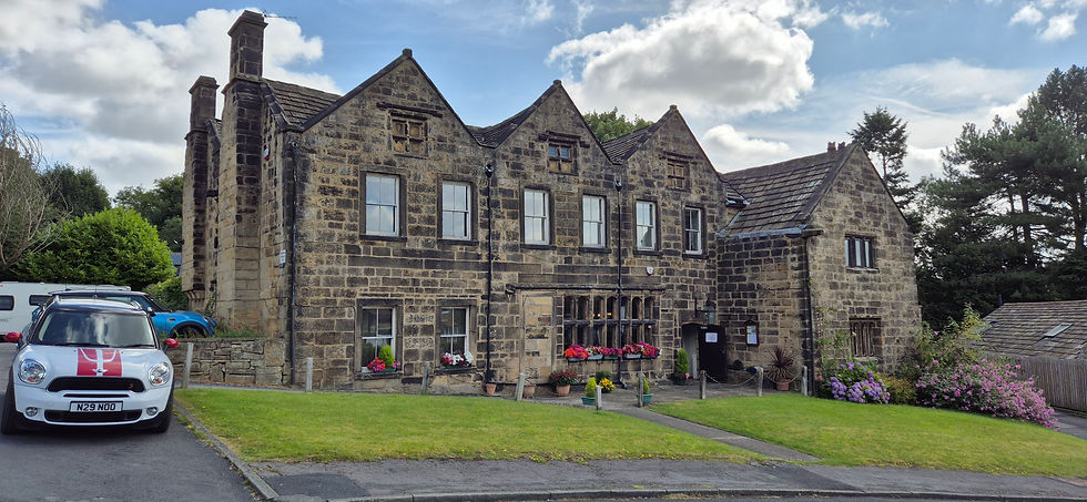
Baildon Hall
Returning to Baildon Road, we continue up the hill, passing a war memorial on the corner. Just before reaching a former chapel on the right, turn right down Butler Lane and follow it as it becomes a cobbled path joins the end of Church Hill. Follow this to Hallcliffe, taking a detour to the right to visit Baildon Community Gardens, which was established in 2005 on the playing field of the former church school. Turn left the school building, taking a detour into the churchyard of the Church of St. John through a handsome lych gate if you wish. The Church is Grade II-listed and dates from 1848, with the tower added in 1928.
Follow Hallcliffe until it ends at Baildon Road, where the Frances Ferrand Memorial Fountain can be seen. Known locally as the “potted meat stick” due to the colour of the pink granite from which it is made, this was built by Baron Amphlett of Somerset as a memorial to his mother-in-law and was moved to its current location in 1986. Turn left and then cross the road at the pelican crossing, looking out for Wesley House on the right; this is a former Wesleyan Methodist preaching house dating from the eighteenth century, where John Wesley preached and on his fourth and final visit to Baildon. Just past this, bear right along a signed public footpath that climbs stone steps (known locally as the “Bedlam steps”, because the noise once made by people in clogs regularly using them sounded “like Bedlam”) to join the end of West Fold, where the Baildon Moravian Church can be seen on the left. Another Grade II-listed church, this was built c.1868. Walk past this to where West Fold ends at Westgate, and look out for the Bulls Head on the right.
Turn left and follow Westgate as it becomes West View. When it ends at Newton Way, turn right, shortly passing the Baildon Methodist Church on the right, which dates from 1890. Continue past this, following the road as bends right and becomes The Grove, and when this ends at a roundabout, turn left, looking out for the Market Cross and the stocks in front of it. The cross probably dates from the seventeenth century and was restored during the twentieth, whilst the stocks likely date from the early eighteenth century; both are Grade II-listed. Look right across the road to see The Angel public house, then proceed past the stocks and the cross and follow Northgate, soon passing another pub – the Grade II-listed seventeenth century Malt Shovel Inn – on the right.
Follow Northgate as it climbs gently uphill and out of the town, becoming first Moorgate and then Hawksworth Road. Shortly after passing a cattle grid in the road, turn left and follow a footpath between part of Baildon Golf Course on the right and houses on the left, eventually leaving both behind and ascending straight ahead onto Baildon Moor. This forms part of Rombalds Moor, which includes the more famous Ilkley Moor, which we shall be visiting when we eventually reach the end of the Wharfedale line. Keep walking straight ahead, ignoring any turnoffs, eventually reaching Baildon Trig Point, from where there are excellent three hundred and sixty degree views of the surrounding area. This is the first trig point we have encountered on our tour of Yorkshire by railway, and we shall encounter a second on this walk. More properly known as triangulation pillars and dating from 1936, these approximately four foot tall concrete pillars were erected on high ground all over the country as part of a major project by the Ordnance Survey to map out the shape of Great Britain.
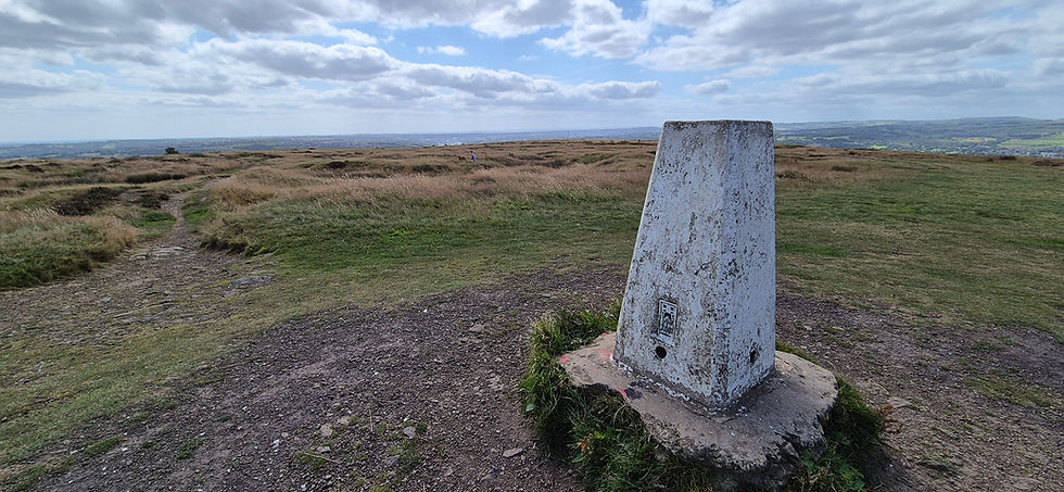
Baildon Trig Point
Continue straight ahead past the trig point, following the path downhill to a bridleway. Turn right and follow this all the way to Bingley Road. Turn right, then cross over and follow a signed footpath diagonally across another part of Baildon Golf Course. At a crossroads of paths, continue straight ahead, and when the path ends at a junction, turn right and continue to Hawksworth Road. Cross this and continue straight ahead along another footpath, bearing right at a junction to climb a hill to the second trig point on the walk, Baildon Common Trig Point.
Turn left and follow a path along a ridge, eventually reaching Moorside. Turn left and walk down this, and just before it reaches a group of buildings, turn right through a gate and follow a path through two more gates, eventually reaching a track. Turn right and follow this, then take the second path of the left and follow it to Tong Park Dam, which once provided water to a mill. Turn right and follow a path back uphill and through a farm gate, eventually reaching Lonk House Lane. Turn left, passing Tong Park War Memorial (restored in 2018 after many years of neglect to celebrate the centenary of the ending of World War I), then stay on the lane as it curves right and then left, eventually ending at Hollin Head.
Turn right along Hollin Head, then right again to follow a signed footpath that turns left, then right and then left to reach Langley Lane. Cross this and continue straight ahead, following another public footpath that eventually reaches Old Langley Lane. Bear left along another footpath, which joins the end of Silson Lane. Follow the lane downhill to Roundwood Road, then turn left and finally turn right along a path to return to the railway station.
From Baildon, we proceed along the Wharfedale line, but skip the next station – Guiseley – as we have already visited it during our trip around the City of Leeds. We thus alight at the next station, which serves the small village of Menston…
Comments