Bingley Trail
- Paul Clarke
- Jul 23, 2024
- 4 min read

Bingley is a market town one stop along the line from Saltaire. It has plenty of history and has been around since the time of the Domesday Book, but despite a charming fifteenth century church and plenty of other old – and in many cases listed – buildings, its best known feature (more on which below) dates from the Industrial Revolution, when Bingley expanded rapidly like so many of the other towns we have already visited on our tour of Yorkshire. The walk also includes Gilstead, once a separate village, but now conurbated with Bingley due to twentieth-century urban expansion.
Bingley Railway Station opened in 1892 and it retains its original – now Grade II-listed – buildings; it replaced the original Bingley Station, which opened in 1847 on the Leeds and Bradford Extension Railway. We leave the station via Platform 2 and walk up the steps or ramp to the main entrance. From here, turn left, cross Wellington Street, then bear right along an alleyway, passing the Library tap – the former Mechanics’ Institute, marked by a blue plaque – on the right. Turn right and then bear left across Bingley Town Square to the Market Square Tavern, then take a sharp left turn and walk to Myrtle Place, passing both the Old Market Hall and the Butter Cross on the right. The Butter Cross is believed to date from the thirteenth century, whilst the Old Market Hall was built in the late seventeenth or early eighteenth, and was moved to its current location in 1984; both are Grade II-listed.
From here, we cross the road and continue directly ahead along Myrtle Grove, passing Bingley Pool on the right. Continue straight ahead into Myrtle Park, looking out for the bandstand on the left. Follow a path to Bingley War Memorial, looking right across a bowling green for a view of Bingley Town Hall (originally a house called Myrtle Grove, which was dates from c.1770), then bear right and pass a play area before descending steps down a hill. Turn right at the bottom and walk to the path running alongside the River Aire, then turn right and follow the path all the way to Millgate, where the historic Ireland Bridge crosses the river to the left. This Grade II*-listed structure dates from 1686 and replaced an earlier timber bridge.
Turn right, then left past the Old White Horse Inn, a Grade II-listed seventeenth century coaching inn. Follow Old Main Street to the Church of All Saints. The handsome gritstone church dates from the fifteenth century and was restored in the nineteenth, and is now Grade II*-listed.
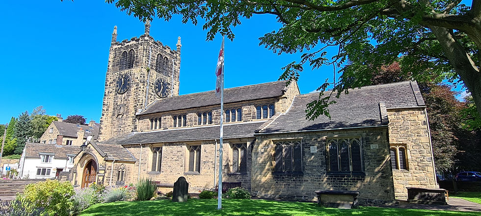
Church of All Saints
After passing the church, bear left along Bailey Hills Road and follow it as it bends right and then left to reach the entrance to Bingley Cemetery. Take a detour to visit the cemetery, which has a pair of well-maintained chapels; otherwise, continue along the road (now Cemetery Road), which hairpins round to end at Keighley Road.
Turn right and follow Keighley Road, then cross over and follow a pedestrian bridge that crosses both the railway track and Sir Fred Hoyle Way to end at the towpath of our old friend the Leeds and Liverpool Canal. Directly opposite are the Bingley Three Rise Locks No. 22-24. These make for an impressive sight, but the best is yet to come: after taking a detour to the right for a view of Bowling Green Mill on the other side of the canal, head left along the towpath, soon reaching Bingley Five Rise Locks No. 25-29. Considered one of the “Seven Wonders of the Waterways”, the Five Rise Locks opened in 1774 and raise the canal eighteen metres, making them the steepest lock staircase in Britain. Logistically challenging for boaters, they are a remarkable example of canal engineering.
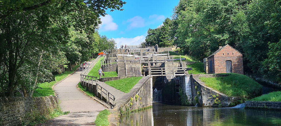
Bingley Five Rise Locks
At the top of the Five Rise Locks, cross the canal via the Five Rise Locks Swing Bridge No. 200 (there is a canal side café on the left here) and continue straight ahead along Beck Lane to a mini-roundabout. Turn right (still on Beck Lane) and follow this past allotments on the right before turning left along a signed footpath to Gawthorpe Drive. Turn right and follow this for a short distance, then when it bends right and becomes Gawthorne Lane, continue straight ahead along a footpath (Spa Lane) to reach Park Road. Here, turn left, then cross the junction with Lady Lane and bear slightly left to enter Prince of Wales Park.
Take the next right hand turn and follow a path through the park to Parkside. Cross this and continue straight ahead along a signed bridleway, immediately bearing left along a footpath running slightly uphill through trees. Continue along this path, ignoring any turn offs, to reach Gilstead Crag, a popular site for bouldering. At a fork, bear right past the crag and follow the path straight ahead, ignoring another turn off close to a ruined stone building, eventually reaching the end of Rombalds Drive. Bear slightly right, continuing to follow the signed public footpath, to reach the bottom of Fernbank Drive as it ends at Gilstead Lane.
Turn left along Gilstead Lane, shortly passing the Church of St. Wilfrid on the right, then turn right and follow Primrose Lane downhill. Just after the lane bends sharp right, turn left and follow a footpath to the Leeds and Liverpool Canal, crossing straight ahead over Dowley Gap Changeline Bridge No. 206 and turning right to regain the towpath. Follow this past Dowley Gap Locks No. 20-21, Scourer Bride No. 205 (where the Fishermans Inn can be visited on the left), Maud Bridge No. 204, a pipe bridge, and Dubb Bridge No. 203, then on reaching Park Bridge No. 202 turn left in front of it and follow a path to the top. Turn left and cross Britannia Bridge over Sir Fred Hoyle Way, then bear right along Ferrand Street. Finally, turn right and follow a path across a supermarket car park, then continue straight ahead along Waterloo Road to return to the railway station.
From Bingley, we now once again proceed along the Airedale line, but only for a short trip. The next station is Crossflatts, and like Bingley it provides the start for a circular walk that once again includes a substantial stretch of the Leeds and Liverpool Canal.


Comments