
It is perhaps an exaggeration to say that Keighley lies in the heart of Brontë country (a term used to describe an area of the south Pennines where the Brontë sisters lived and wrote their famous novels), but it’s certainly in the same area, and provides a heritage railway link to the village of Haworth, where the sisters made their home. Keighley is an historic market town transformed – like so many others – during the Industrial Revolution, which saw the building of several large textile mills. It’s an old settlement, with a name derived from “Cyhha's farm or clearing” and is recorded in the Domesday Book of 1086. It has been a town since 1305, when King Edward I granted it a market charter. As well as taking in many of the town’s historic buildings, the work also reunites us once again with the Leeds and Liverpool Canal, continuing on its way into the Pennines.
Keighley Railway Station was originally opened by the Leeds and Bradford Extension Railway in 1847, slightly further up the line from its current location. It was rebuilt in its current location in 1883 and retains its original buildings, which are Grade II listed. Platforms 1 and 2 are used by National Rail trains, whilst platforms 3 and 4 form the northern terminus of the Keighley & Worth Valley Railway, the aforementioned heritage branch-line that runs for five miles to Oxenhope and stops at Haworth along the way. We leave the station on Bradford Road and turn left, then take the next left turn along Low Mill Lane (shortly passing a Grade II-listed water tower visible on the station platform on the right). When the road bends sharp left under a railway bridge, continue straight ahead along a path and follow this as it passes beneath the railway line and back again before ending at Park Lane. Turn left and follow The Walk, then bear left along a footpath signed “Worth Way”. Follow this path, which soon joins the riverside of the River Worth, until it ends at Woodhouse Road. Turn right along this then immediately right again along Marriner’s Walk, which eventually joins the end of Marriner’s Road. Continue straight ahead along this until it ends at Worth Way.
Cross over and walk straight ahead to a supermarket car park, then bear diagonally left across this, eventually exiting at the end of Market Street. Follow this for a short distance, then turn left into the churchyard of Keighley Parish Church.
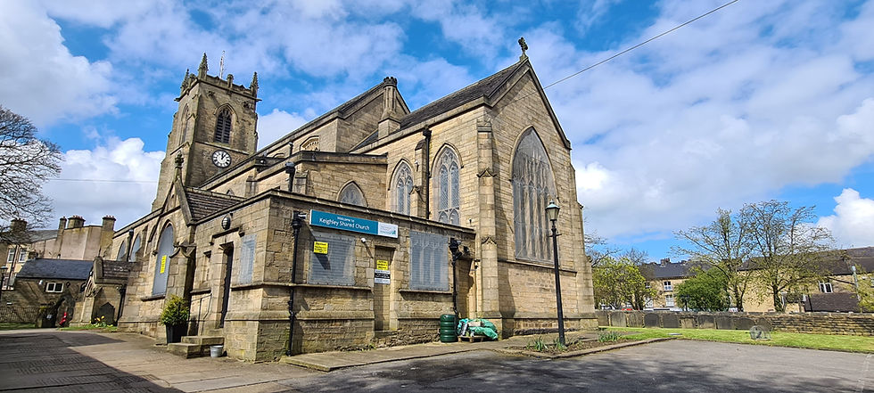
Keighley Parish Church
The first of two Grade II-listed churches on the walk, this dates from 1848. Walk to the left of the church to exit the churchyard on Church Street. Directly opposite – and adjacent to each other – are the Red Pig public house and the Commercial Hotel. Turn right and walk to the end of the street, then continue straight ahead along North Street, shortly passing Arcade Chambers on the left. Just past this, take a short detour along Russell Street to see Shahjalal Jami Masjid & Jamiah Quraniah. This Grade II-listed mosque was originally built as a Methodist Chapel in 1846.
Continue along North Street, next passing Natwest Bank and Barclays Bank (both on the left), then cross over and turn right along Bow Street, passing the Town Hall (Grade II listed and built in 1902). Follow Bow Street as it bends left around the Town Hall, then bear left along Cooke Street, passing the former School Board Offices on the right. Immediately turn left and walk past Keighley Cenotaph to reach North Road once again. Turn right, cross the junction with Cavendish Road, then cross North Road and continue in the same direction, passing Keighley Library (an impressive building dating from 1904) opposite the junction with Cavendish Road. Immediately past this, take a detour to the left along Albert Street to see the former Public Baths. Proceed along North Road, passing the Livery Rooms on the left, followed by the Picture House Cinema on the right. The cinema opened in 1913, and is one of the oldest in Britain. Just past the cinema, the Roman Catholic Church of St. Anne can be seen on the left. This is the second of the two Grade II-listed churches on the walk, and was built in 1840 by renowned church architect Augustus Welby Northmore Pugin.
After passing the church, bear left along Spring Gardens Lane, then bear right to enter Devonshire Park. This opened in 1888 on land gifted to the town of Keighley by the Duke of Devonshire, in honour of the Queen’s Jubilee. Follow paths left and then right through the park to exit on Mayfield Road, then turn right to return to Spring Gardens Lane. Turn left and then at the junction with Castle Road, bear right to enter Cliffe Castle Park. Continue straight ahead, then bear left to visit Cliffe Castle.
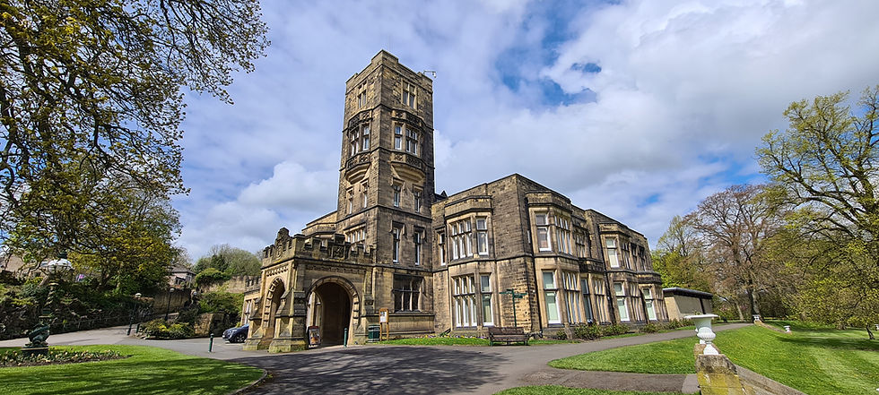
Cliffe Castle
This isn’t actually a castle, but rather a Grade II-listed house, originally built in 1828 as Cliffe Hall, extended (with the addition of towers) in 1875-1880, and renamed Cliffe Castle in 1878. The house and grounds were purchased in 1949 by the Keighley Corporation; the house is now a museum, and the grounds are a public park.
From the castle, walk downhill to a lake, then bear left and eventually exit the park on Skipton Road. When the road bends left, cross over and enter Utley Cemetery, following a path to the left to reach the entrance lodge. Turn right, passing a cemetery chapel on the right, then bear left past the distinctive Butterfield Family Chapel and Vault. Another Grade II-listed building, this was constructed c.1875 for the Butterfield family, who for a time were the owners of Cliffe Castle. Bear left and then right again, crossing Cemetery Road, and then a bridge over the railway track, which bisects the cemetery. On the other side of the railway, follow a path to the left, eventually exiting on Parker’s Lane.
Turn right and follow the lane across over the bridge over the A629, and stay on it as it bends left and then right to cross a bridge over the River Aire. Follow the lane across Keighley Golf Course, eventually following a public footpath past the Club House and then left to reach the towpath of the Leeds and Liverpool Canal. Booth's Swing Bridge No. 195 is directly in front. Do not cross the bridge, but instead turn right and follow the towpath for over a mile, passing Leache's Swing Bridge No. 196 and eventually leaving the towpath at Stockbridge Swing Bridge No. 197, which carries Bar Lane over the canal.
Turn right and follow Bar Lane to Bradford Road, then turn right again, shortly crossing a road bridge over the River Aire. Just after passing the Stockbridge Arms on the right, turn left along Aireworth Road. Turn right along Aireworth Grove, then immediately turn left and follow a riverside path next to the River Worth. This shortly passes under the Airevalley Road, and eventually ends at Dalton Lane. Here, turn right, passing the huge Dalton Mills on the left. Built in the nineteenth century, this is a Grade II*-listed textile mill which was gutted by fire in 2022, destroying much of its interior. Despite this, the exterior remains intact, although its future is currently uncertain. Finally, when Dalton Lane ends at Bradford Road, turn left to return to the railway station.
From Keighley, we have one more stop to make along the Airedale Line before it leaves the City of Bradford, at a railway station named after a town and a village, both of which it serves.
コメント