
Low Moor Trail
- Paul Clarke
- Jul 21, 2024
- 5 min read

Low Moor is one of Bradford’s most southerly suburbs, technically a village that prior to 1790 was merely a hamlet. Change and significant growth came with the establishment of Low Moor Ironworks in 1791, which originally started life as a wrought iron foundry on what was previously a large part of the Royds Hall estate. It survived until 1957, when wrought iron production ceased, after which steel was manufactured on the site. The village increased in size dramatically to meet the needs of the workers at the ironworks, with houses, pubs and churches being built. Much of the ironworks site has been redeveloped, although part of it is currently home to the Solenis chemical manufacturing plant and Low Moor retains plenty of industry. Whilst Low Moor could slightly harshly be described as the sort of place most people wouldn’t bother visiting unless they happened to live there, the route takes in a small number of listed buildings, some woodland and countryside walking, a Victorian park, and a nature reserve.
Low Moor Railway Station only opened in 2017, as part of Metro’s admirable and ongoing program of improving public transport infrastructure in West Yorkshire. Unsurprisingly, it is a simple twin-platform station, albeit with a large lift bridge connecting the two. Low Moor originally had another railway station some distance away from the current one, which opened in 1848 and closed in 1965; no trace remains and the site is now occupied by modern industrial buildings. From the station, we turn right along New Works Road and follow it as it gradually curves right around the Solenis site. Just after reaching a mini-roundabout, look out for the Royal public house on the left. Continue past this, then turn left along St Mark’s Terrace. At the end of the road, continue straight ahead along a path, then turn right into the churchyard of the Church of St. Mark. The first of two Grade II-listed churches on the walk, this now-redundant one was built in 1857; it closed in 2002 and was converted into a private residence. Continue past the church to exit the churchyard on Huddersfield Road.
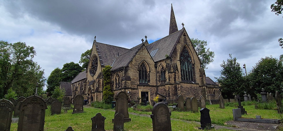
Church of St. Mark
Cross the road and climb steps directly opposite to reach Woodside Road, then turn left. We now follow this for some distance (crossing over to the opposite side at a pedestrian crossing), and eventually turn right along High Fernley Road. Follow this as it becomes an increasingly rural track and eventually a footpath and enters Old Hanna Wood. On reaching a crossroads of paths, turn right and then immediately left through a gap in a wall. Walk through the edge of the wood to reach a field, and a follow a path diagonally across this. When the path passes through a row a trees, bear right at a fork and follow the path to a stile. Cross this and follow a path straight ahead across a field to a metal gate. Continue straight ahead across two more fields, then at the top of the second one bear slightly left through a wooden gate. Continue to follow the path across another field, cross directly over a farm track, and continue straight ahead along the next field, then turn right immediately after passing a group of farm buildings. Follow the path to Royds Hall Lane, turn right, and then immediately left along Royds Hall Cottages, passing Royds Hall on the right. The Grade II*-listed hall is cited as one of the best surviving manor houses in the Bradford area, although sadly it is barely visible from the road. It dates from 1640, with later additions.
We now follow Royds Hall Cottages past the hall, then just before the lane bends right, turn left and follow a footpath downhill to the edge of Royds Hall Dam. This is the remnant of one of two holding basins for Low Moor Ironworks and is now used by anglers.
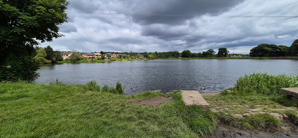
Royds Hall Dam
Turn sharp left and follow the path next to the dam to reach Longdale Road, turn left and follow this to Fenwick Drive, and then turn right and follow this to Abb Scott Lane. Cross this and continue straight ahead into North Bierley Cemetery. Walk across this and exit on Cemetery Road, then turn right. Follow the road slightly downhill, then bear left into Harold Park. Take the next left turn and follow a path across the park, passing gardens on the left. Turn right at the end of Jug Dam and follow the path to the larger of the park’s two dams, passing a memorial sundial dedicated to cricketer Lieutenant Frank Milligan, who died in 1900 at the age of 30 during an attempt to relieve the Siege of Mafeking during the Second Boer War. Walk past a monument to Harold Gathorne Hardy, a former manager of Low Moor Ironworks, who in his role as Chairman of the Enclosure Commissioners helped to create the park now named after him.
Turn left along the edge of the dam, then turn right at the corner and follow a path to exit the park by the Park Lodge. From here, turn right along Park Road and follow this until it ends at Common Road. Turn left and follow this, shortly passing Hill Top Primary School on the left, and on reaching the crossroads with Huddersfield Road, continue straight ahead (still on Common Road). Just before Common Road ends at Cleckheaton Road, bear right to enter a small garden, with a war memorial in the centre. Cross Cleakheaton Road at the nearby Zebra crossing, then continue straight on along Park House Road, passing between the Chapel House Inn on the left and the Church of the Holy Trinity on the right. Both are Grade II-listed: the inn dates from the late seventeenth century, whilst the church predates Low Moor Ironworks, having been built in 1606 by William Rookes of Royds Hall and originally known as Wibsey Chapel.
Continue along Park House Road, shortly passing a fenced-off dam on the left, which once provided water power to a wireworks. Proceed past this, and when the road becomes a path continue straight ahead along a public footpath across South Bradford Golf Course. The path ends at a junction in a belt of trees; here, turn right and follow the path through the wood, with a railway track (separated from the path by a metal fence) on the left. Eventually, the path runs through Raw Nook (or Railway Terrace) Nature Reserve. This thirteen acre site was originally owned by British Rail and housed engine sheds and sidings associated with the original Low Moor Railway Station, all dismantled during the nineteen sixties. It consists of a mixture of heathland and woodland, along with a small seasonal pond, and despite its modest size is home to a plethora of flora, insects, birds and nocturnal mammals. Continue through the reserve and exit onto Lockwood Street. Turn left and follow this between a pair of public houses – the George Hotel on the right and the Black Horse on the left – to reach Cleckheaton Road. Finally, cross this, walk straight ahead along New Works Road, and immediately turn left to return to the railway station.
From Low Moor we return to Bradford Interchange, and from there to Bradford Forster Square to travel along the Leeds-Bradford line to our next stop, at the village of Apperley Bridge.


Comments