
Menston Trail
- Paul Clarke
- Aug 4, 2024
- 4 min read

Menston was originally a small farming community, which today has become a commuter village with modern housing estates for people working in Bradford and Leeds. The walk takes in the small village centre, but first passes through the grounds of what was once one of the West Riding’s four lunatic asylums, before looping around through pleasant open fields.
Menston Railway Station was opened in 1873 by the Midland railway and was redeveloped in 2000; the surviving original station building was brought back into use with a ticket office and waiting room. We leave the station via the northbound platform and turn left along Station Road. Just before this ends at Bradford Road, turn right along Leathley Lane and follow it to a mini-roundabout. Here, we turn right again and follow Low Hall Road and stay on this when it bends left and becomes Farnley Road. Take a left turn into Menston Park and walk straight ahead across this, then bear right to leave on Bingley Road. Cross straight over at the pedestrian crossing and continue straight ahead along a path between trees. Just before this bifurcates and ends at Kingsdale Close, turn left and follow a path that shortly bends right and ends at High Royds Drive.
Turn right and then left along Ingle Lane and follow this until the former buildings of High Royds Hospital appear on the right. Originally opened as the West Riding Pauper Lunatic Asylum in 1888, this later become High Royds Hospital for psychiatric inpatients before closing in 2003 and being converted into private accommodation.
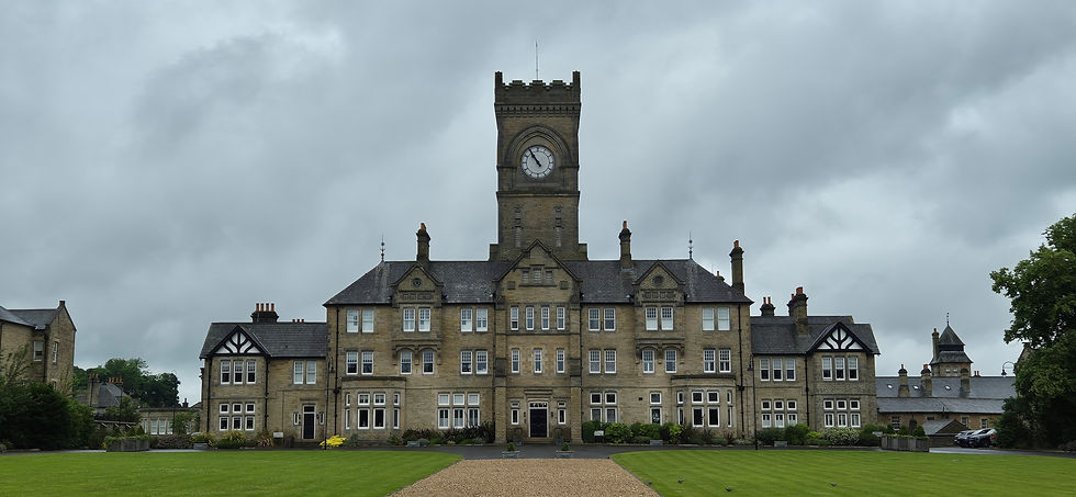
Former High Royds Hospital administration building
Turn right and walk past the first building, then turn left and walk to Ingle Lane. Turn right and walk to a junction, looking right for a view of the former administration building (with its distinctive clock tower), which is Grade II-listed and has the typical Victorian grandiosity common to most former asylums. Turn left along Guiseley Drive, and just after passing the junction with Wharfedale Avenue on the right, turn right along a footpath. Take the next left turn and follow a path over Mire Beck, following the path along the edge of a field as it runs gently uphill to a former farm now used as a cat shelter. Here, turn right and climb over a stile to follow a path along the edge of two fields, eventually reaching a farm building on the left at a junction.
Turn right and follow a track slightly downhill, again crossing over the Mire Beck. Continue past another farm on the right, then turn left and climb over a stile to follow a waymarked public footpath diagonally across a field to reach Bingley Road. Here, turn left, then shortly turn right over another stile to follow a public footpath diagonally across another field. Pass through a gap in the wall, walk through a copse of trees, and continue across another field to Derry Hill. Here, we turn right and follow this to the centre of Menston village, until it ends at Main Street. The Menston Arms, a traditional village pub, is located on the lefthand corner.
Turn right and walk to the junction with Burley Lane. Another pub, the Malt Shovel (which is Grade II-listed and believed to date from the early nineteenth century), is located on your right and Menston Methodist Church is located further along the road on the left.
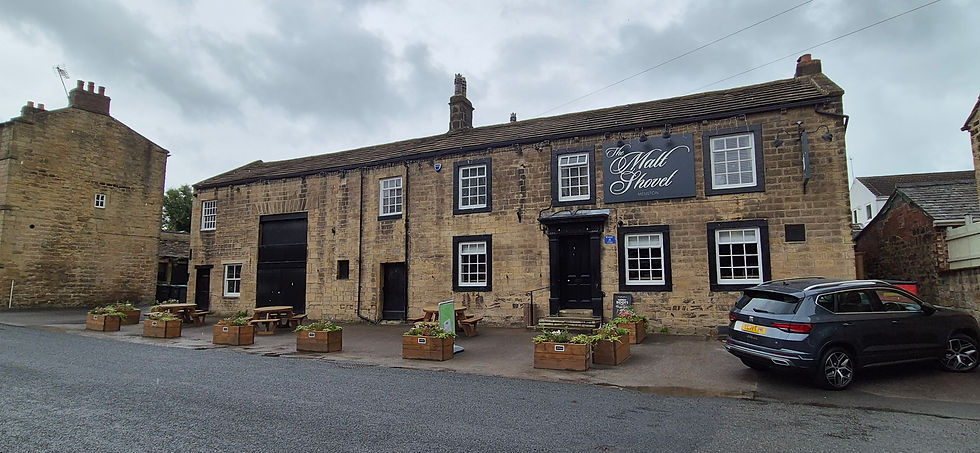
The Malt Shovel
Turn left along Burley Lane and walk past the modest Church of St. John the Divine on the left. Turn right along Fairfax Road, then just after passing the junction with Fairfax Gardens on the left, turn left and follow a path between houses to Westbourne Drive. Cross straight ahead and follow another path over a bridge over the railway track, continuing straight ahead on the other side and staying on the path until it ends at Burley Road.
Turn left and follow Burley Road, looking out for God’s Acre Cemetery on the right. Immediately after passing this, turn right and follow a path into Milner Wood that shortly bears left and climbs steps to reach a former branch of the Otley and Ilkley Joint Railway. This branch opened between Otley and Ilkley in 1865 and closed in 1965. Turn right and follow the track bed, which eventually becomes muddy and overgrown; here, bear left up a steep path and follow this as it turns parallel with the former railway line, eventually descending (or rather, scrambling) down a steep slope to reach Bradford Road. Turn right and follow this, which soon bends left and becomes Otley Road, eventually reaching a roundabout. Cross this, looking out for the Fox public house on the left. Walk across the pub car park and follow a signed public footpath to Brooklands Lane. Turn left and follow the lane as it bends right, then turn left along another footpath, which ends at the southbound platform of Menston Railway Station.
From Menston we resume our journey along the Wharfedale line, but only for a short distance, as we alight once again at Burley in Wharfedale.


Comments