Pudsey Trail
- Paul Clarke
- Jul 20, 2023
- 5 min read

Updated: Jul 21, 2024
Pudsey is the penultimate stop on our tour of the City of Leeds, and a market town that, in spite of merging into adjacent suburbs of Leeds to the east and Bradford to the west, hass retained the feel of a town in its own right. It has been inhabited since at least the time of the Domesday Book, in which it is mentioned as Podechesai, and like most of the places we have visited around Leeds it expanded in the eighteenth and nineteenth centuries following the Industrial Revolution as a centre for wool manufacture. It has also been famous for cricket since the nineteenth century, and several well-known names in cricket learned to play in the town. The name Pudsey incidentally is etymologically obscure, but may mean “Pudoc’s island”; nowadays, the town’s name is well-known because it has been lent to Pudsey Bear, the mascot of the BBC’s annual Children in Need fundraiser, since the bear’s designer’s grandfather was once the town’s mayor.
Pudsey once had two railway stations in the town, both of which fell to the Beeching Axe. The current station – New Pudsey – is located a mile from the town and opened in 1967; it was one of the first stations specifically built for the benefit of motorists, explaining its location at the convergence of several main roads. It is a typical modern two-platform affair with waiting shelters, although there is a (rather ugly) ticket office in the station car park, which also has toilets. From the station, turn right in front of the ticket office and follow a signed public bridleway to Ring Road. The path crosses this through a gap in the central reservation but with no pedestrian crossing, making it somewhat perilous. Cross with extreme care and on the opposite side of the road proceed straight ahead uphill to a small copse called Owlcoates. Turn right and follow path next to a wood, and at a junction bear left, continuing along the path, which now has houses on the right, to Owlcoates Road. Here, turn left and then right along Sunnyridge Avenue, following this downhill until it ends at Waterloo Road.
Turn left and then right along Bradley Lane, following it as it turns left to reach Gibralter Road. Turn left and follow this uphill, then take a sharp right turn along Delph End. When this ends, continue straight ahead along a path through the woods surrounding Round Hill, which offers pleasant views over the surrounding area. The path eventually ends at Smalewell Road; continue straight ahead along this, and at a junction turn right, still on Smalewell Road, shortly passing a pub called the Fox & Grapes. Continue past this until the road ends at Greenside, then continue straight ahead along Station Street to reach Carlisle Road, passing the Royal – another public house – on the corner. Turn left and follow Carlisle Road to Chapeltown, passing a small memorial garden named Sparrow Park on the left.
Where Carlisle Road meets Chapeltown, Pudsey’s large town war memorial can be seen. To the left along the road is another public house, the Golden Lion, whilst just past the war memorial on the right is a former Conservative Club, now the 147 Sports bar. Turn right past the memorial and Sports Bar, then bear right again along Radcliffe Lane, passing the Parish Church of St. Lawrence on the left.
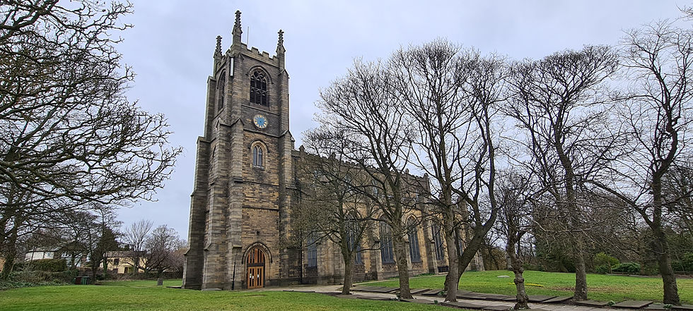
Church of St. Lawrence
This was built c.1821 and is Grade II-listed Just after passing the church, turn left into Pudsey Park and walk diagonally across it, passing the bandstand, to reach the playground. Take the first left past the playground to reach Mulberry Street and continue straight ahead along this to where it shortly ends at Church Lane, passing the currently closed Butchers Arms pub on the corner.
Turn left and follow Church Lane to Pudsey Masonic Hall (next to this is a former church now converted into a residential dwelling) and turn right, following Lower Tofts Road uphill to Pudsey Cemetery. Turn right into this, shortly bearing left to reach the cemetery chapels; towering and impressive, they have sadly fallen into dereliction, like so many cemetery chapels we have encountered in our exploration of Yorkshire, but happily a local group is campaigning to restore them. Follow the path through the arch between the chapels and continue straight ahead down steps to exit the cemetery on Cemetery Road. Turn right and follow this to a crossroads, then right along Lidget Hill and follow it to another crossroads, where Pudsey Market can be seen just to the right. Turn left, passing a former National Westminster Bank on the corner and follow Lowtown, passing the large and impressive Town Hall on the right.

Pudsey Town Hall
Take a detour to the left to visit the Worlds End public house (originally a seventeenth century house and attached cottage), just past which is the currently derelict Grade II-listed Trinity Methodist Church, built c.1899 and the dome of which can be seen from Pudsey Cemetery.
Turn right just past the Town Hall and follow Manor House Street to Robin Lane, passing the Crossed Shuttle on the left. Turn left down Robin Street, passing Manor House on the opposite side of the road, which bears a red plaque that reveals its original purpose as a school. Bear left along Longfield Road, passing St. Andrew’s Methodist Church on the corner, and shortly bear left down a path and under a former railway bridge (the demolished Pudsey Lowtown Railway Station was located a short distance to the left along the disused railway line that the bridge once carried). Continue straight ahead along an alleyway between allotments to reach Crumbles Road, then turn left, then right along Crimbles Terrace to reach Kent Road.
Turn left and walk to a crossroads; to the left, the former Crown Inn can be seen. Turn right along Lowtown, shortly passing another former pub – the Victoria Hotel – on the corner of Hough Side Road (a short distance down Hough Side Road is another, still open, pub called the White Horse). Proceed along Lowtown which becomes Swinnow Road, passing the Britannia pub on the right, then turn left into Lane End and follow this to a junction, continuing straight ahead along Mount Pleasant Road. When The Lanes appears on the right, take a detour down it to visit Saint Joseph’ Catholic Church; otherwise, bear right along Grange Terrace when the main road bends left. The road bends right and then right again; just before the second right turn, turn left and follow a path past a school to reach North Street. Turn right and then take the fourth left turn along Laurel Mount, which shortly ends at Richardshaw Lane.
Turn left and follow the road to the Grange, a large and impressive former Grammar School on the left-hand side of the road. Turn right along Brunswick Road and follow it to the crossroads with Surrey Road then, turn right again and walk downhill to Ring Road. Turn left and then right to follow the subway beneath the road and on the other side turn left and follow a path to a supermarket car park. Bear right across this, then turn right and walk past the shops, continuing straight ahead to reach the edge of the railway line. Turn left and follow a path next to this, eventually returning to the station.
Pudsey almost marks the end of our of the City of Leeds metropolitan borough, but there is one final station to visit. And so, we head back to Leeds and then set out once more, this time on the Wharfedale Line…


Comments