
Saltaire Trail
- Paul Clarke
- Jul 21, 2024
- 4 min read

The Victorian model village of Saltaire is one of Yorkshire’s most fascinating tourist destinations, at least for anyone interested in industrial heritage. A UNESCO World Heritage Site since 2001, it was built by Sir Titus Salt (a statue of whom we saw on the Frizinghall walk), between 1851 and 1871 and is sited on both the River Aire and the Leeds and Liverpool Canal. It is, of course, named after both Salt and the river. Most of the buildings dating from the time of the village’s original construction are Grade II or II*-listed, and the United Reformed Church is Grade I-listed. The walk also includes another section of the canal, as well the scenic Shipley Glen, with its fascinating funicular tramway.
Saltaire Railway Station opened in 1856 and closed in 1965; it was reopened in 1984, but the original stone buildings were sadly demolished in 1970. The first part of the walk is through the centre of the village, and it is worth meandering to appreciate the architecture. From the station, we turn right along Victoria Road and follow it to the Shipley College Salt Building, opposite which Victoria Hall can be seen.
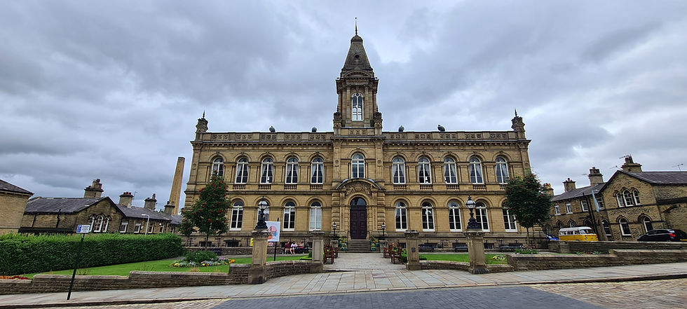
Victoria Hall
Turn left in front of the latter and follow Lockwood Street to Exhibition Road, then turn right, passing the Shipley College Exhibition Building to reach Saltaire Road. Turn left, passing Fanny’s Ale House (the former police station), then right along Park Street and follow this to Bingley Road. Next, we turn right, then take the next right along Victoria Road, passing the Almshouses on the left, shortly followed by the former hospital on the right. On reaching a crossroads, continue straight ahead, then turn left along Titus Street and left again along George Street, passing Saltaire Methodist Church on the left. Turn right and follow Saltaire Road, then just before it ends at Bingley Road, turn right along Clarence Road. Take a detour to the right along Albert Road to view Saltaire Primary School; otherwise, continue along Clarence Road, passing the former tram shed on the left.
Having left the village behind, we now stay on Clarence Road as it becomes Hirst Lane, eventually following a bridge over the railway track to reach Hirst Mill Swing Bridge No. 207 over the Leeds and Liverpool Canal. Just before this, Hirst Wood Nature Reserve can be visited on the right. Cross the swing bridge, taking a short detour to the right to see Hirst Lock No. 19, otherwise turning left to follow the canal all the way to Dowley Gap Aqueduct, which carries the canal over the River Aire. Just after crossing the aqueduct, turn right and follow a footpath along the riverside, looking right for a glimpse of aqueduct. Continue to follow the riverside, until Hirst Mill and weir can be seen on the right. Just after passing the weir, follow the path to the left; at a fork, do not cross a footbridge, but turn left and follow a path slightly uphill to Higher Coach Road. Turn right and then just after crossing a bridge over Loadpit Beck, turn left and follow a footpath uphill and into woods to reach Shipley Glen, the crags of which are popular with rock climbers.
Follow the path to the top of the crags, then turn right along the path along the top, eventually reaching Glen Road. Bracken Hall House Countryside Centre can be seen on the opposite side of the road and offers free admission. Turn right and follow the road, passing the Old Glen House pub and tea rooms on the right. Continue straight ahead (now on Prod Lane) until it ends, then continue straight to the top station of Shipley Glen Tramway. This funicular tramway was originally opened in 1895 to allow access to various long-vanished attractions at Shipley Glen, and has been operated by a charitable trust since 2002. Follow a path running downhill alongside the tramway and on reaching the bottom tramway station, continue straight ahead, then bear right across the tramway car park to reach Higher Coach Road. Cross this and continue straight ahead to enter Roberts Park, with the North Shelter on the left. The park was opened in 1871 by Sir Titus Salt, who helped to design it along with landscape gardener William Gay and is Grade II-listed in English Heritage’s Register of Parks and Gardens.
Turn right and walk anticlockwise around the park, passing the West Shelter, the bandstand and the Sir Titus Salt memorial statue, eventually reaching the East Shelter. Turn right and follow a path to the bridge over the River Aire, looking out for New Mill weir on the left and the Boathouse Inn on the right. On the other side of the bridge, continue to the Leeds and Liverpool Canal, then turn left and right to cross Saltaire Bridge No. 207A over the canal, passing New Mill on the left. On the other side of the canal continue straight ahead along Victoria Road, passing Saltaire United Reformed Church on the right, the huge and impressive Salts Mill (which now houses a shopping centre and gallery) on the left, and then the former Dining Hall (now Shipley College Mill Building), turning right immediately past the last of these to return to the railway station.

Saltaire United Reformed Church
From the model village of Saltaire, we now proceed along the Airedale line a short distance to the next station, located in a pleasant market town which is home to one of the most impressive structures on Britain’s inland waterways…


Comments