
Shipley Trail
- Paul Clarke
- Jul 21, 2024
- 5 min read

Located at a three-way junction of railway lines, Shipley is an historic market town located on the northern edge of Bradford. The name is derived from the Old English for “sheep field” and has been settled since at least the Bronze Age, although during Medieval times it consisted largely of a small settlement at a crossroads near the River Aire. Like so many towns in the region, it expanded considerably during the Industrial Revolution, with the textile industry flourishing in the area and the building of the Leeds and Liverpool Canal heralding a new crop of mills, some of which have survived and been converted to other uses. Sadly, the Victorian town centre buildings have nearly all been demolished and replaced with, amongst other things, a spectacularly ugly brutalist market hall, but the larger town still includes many fine buildings, and the walk also includes parks, the Leeds and Liverpool Canal, and the River Aire.
Shipley Railway Station was originally opened in 1846 by the Leeds and Bradford Railway; when the Leeds and Bradford Extension Railway was built in 1847, it created a triangle of railway lines, forming an island in the middle in which the current station – built between 1883 and 1892 – is located. It is one of only two remaining triangular railway stations in the United Kingdom, with the other being Earlstown in Lancashire.
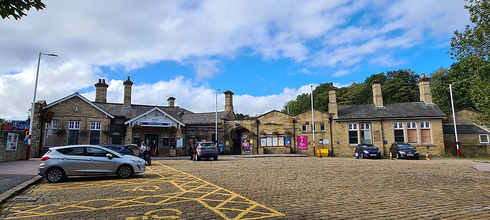
Shipley Railway Station
The station has more than one exit, but we leave it via the Stead Street footbridge exit and turn left to reach Otley Road. Here, turn left again and follow this past the Shipley Conservative Club. This was originally Shipley Old (or Low) Hall and dates from the seventeenth century; it was expanded during the eighteenth. Cross the road and turn right along Dale Street, passing Shipley Market (with its distinctive and previously mentioned brutalist market hall and tower) on the right. Continue straight ahead along Well Croft, then turn left on reaching a large supermarket and continue straight ahead along Manor Lane. Turn right along Westcliffe Road, shortly passing Westcliffe Road Methodist Church on the right. This is the first of three Grade II-listed churches or former churches on the walk and was built in 1875.
Shortly after passing the church, turn right into Shipley Central Park, then turn left and leave the park on Bradford Road. Cross this at the pedestrian crossing just to the right, then turn left and follow the road, soon passing Northcliffe Church on the left. When the junction with Birklands Road appears on the left, turn right to enter Northcliffe Park. This 86 acre park was donated by Sir Norman Rae in 1920, with the land having previously used for coal mining and sandstone quarrying since the seventeenth century. The area was originally called North Clough and later become Northcliff, before gaining an “e” and becoming Northcliffe (Northcliff Dike retains the older spelling). Follow the path straight ahead, then on reaching the bowling green bear right and follow a path that runs gently uphill. Stay on this as it bends left, and at a junction continue straight ahead across the edge of a meadow to enter a band of trees. Continue straight ahead to a path, then turn right.
We now follow the path until just before it reaches a car park serving Northcliffe Allotments, then turn left and follow a steep path downhill through trees to another path running alongside Northcliff Dike. To the left, the headquarters of Bradford Model Engineering Society and the tracks of their model railway can be seen; the society is one of Britain’s oldest model engineering societies. Turn right and follow the path alongside the dike, eventually climbing steps to reach a junction. Take the second right turn, following a well-surfaced path all the way back to Northcliffe Allotments. Just before reaching these, turn left and follow a path across a meadow and down a stepped path through a wood to exit the park on Avondale Road. Turn right, then take the next left turn along Lindisfarne Road. Very shortly, turn right and follow a signed footpath along an alleyway behind houses to reach Farfield Road. Continue straight ahead until this ends at Bradford Road, then cross this and turn right along Kirkgate, shortly passing the Ring O’Bells public house on the right. Soon after this, pass first Shipley Hospital and then the Catholic Church of St. Mary and St. Walburga, both also on the right. Continue along the road, next passing the Church of St. Paul on the left, taking an optional detour to visit the churchyard. The Grade II-listed church was built from 1823-1825.
Just after passing the church, turn left into Crowgill Park and follow paths clockwise around this (passing Shipley War Memorial on route) before returning to Kirkgate. The park was originally a quarry that was later used as the town’s rubbish dump, but was landscaped in 1889 when Shipley Common was enclosed and it was given to the church. Turn left and continue past Shipley Town Hall on the right, an impressive Neo-Georgian building dating from 1932. Just past this, take a short detour along Manor Lane to see the former Wesleyan Reformed Church. This is another Grade II-listed building, which dates from 1863 and has now been converted into a private dwelling. Bear left along New Kirkgate, passing Shipley Baptist Church on the left, and then turn left along Westgate. Follow this until it ends at Saltaire Road, then cross straight over and continue straight ahead along Victoria Street. Just after this crosses a bridge over the Leeds and Liverpool Canal, turn right and then right again to gain the towpath.
Turn right and follow the canal beneath Victoria Street Bridge No. 207B, soon passing under Bridge No. 207E, which carries Salt Mill Road. Stay on the towpath, then just before reaching Salts Mill at Saltaire (which we will see closer up on the next walk), turn right and follow a path that runs alongside the River Aire all the way to Otley Road Bridge. Turn left and cross the bridge, then turn right and follow a path through the car park of several industrial premises, turning right at the end to regain the riverside path. Follow this all the way to the second footbridge over the river, then turn left and then sharp right to cross this, which runs parallel with a railway viaduct on the left. On the other side of the bridge, turn right and follow a track until it ends at Dockfield Road. Cross this to regain the towpath of the Leeds and Liverpool Canal adjacent to Bridge No. 209A, a railway viaduct. Take a detour to the left to see Oddies Swing Bridge No. 210; otherwise, turn right and follow the canal, passing in sequence Dock Swing Bridge No. 209, Junction Bridge No. 208 (which is Grade II-listed and was built with the canal in 1774), and Gallows Footbridge No. 207D.
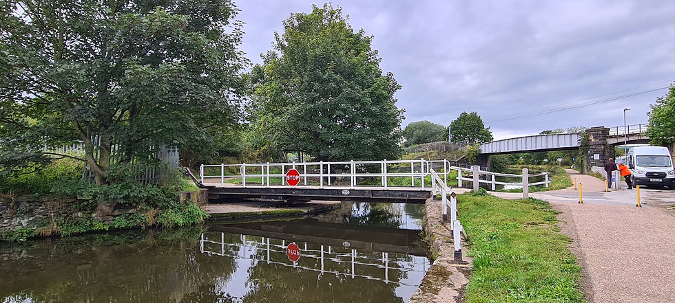
Oddies Swing Bridge No. 210
Finally, on reaching Shipley Bridge No. 207C, leave the towpath and turn left along Otley Road, continuing straight ahead at the crossroads before turning left into Stead Street to return to Shipley Railway Station.
Having completed our walk around Shipley, we now continue along the Airedale line, but not very far. The next stop is at Saltaire, the edge of which we have just skirted on the Shipley walk, and one of the area’s most popular tourist destinations.


Comments